us. They change in appearance, indeed, according to times and seasons, but they alter as true surface features would, not like cloud-belts that gather to-day and vanish forever to-morrow. That the markings are essentially permanent has been known ever since Cassini in 1666 definitely discovered, what Huyghens had thought to detect in 1659, the rotation of the planet, by means of their periodic presentations.
The twelve views we shall here scan are of the nature of a map, made in November, 1894. They represent the ensemble of the drawings from this observatory, for about that date. The details from these drawings were plotted upon a globe, which was then tilted toward the observer at the angle at which the Martian south pole itself was tilted toward--the Earth during November, and photographed at intervals of 30 degrees. The negatives were then made to conform as near as might be to the actual look of the planet. To photograph minute planetary markings directly is, for reasons too long to state here, impossible. The views give between them the whole surface of the planet shown us at what corresponds to our first of August. Thus, neither the polar cap nor the polar sea appear in the pictures, for both had then disappeared. Nor do the southern parts of the so called straits show, for a similar reason. But from a knowledge of the features here presented the reader will find interpolation of any others referred to easy.
Previous to the present chart, the most detailed map of the planet was Schiaparelli's, made in 1888. On comparison with his, it will be seen that the present one substantially confirms all his detail, and adds to it about as much more. I have adopted his nomenclature, and in the naming of the newly found features have selected names conformable to his scheme, which commends itself both on practical and on poetic grounds.
We will begin our journey at the origin of Martian longitudes and travel west, taking the points of the
compass as they would appear were we standing upon the planet. As all astronomical pictures are, for
optical reasons, upside down, south lies at the top of the pictures, west to the right, north at the bottom,
and east to the left. Mars rotates as the Earth does, from west to east, so that day as it advances across
the face of the planet follows the order here shown in Plates III. to XIV., the order in which we shall
observe them. Places on the right of the picture are in the morning of their Martian day; places on the
left, in its afternoon. To facilitate reference by longitude and latitude, the globe has been belted by meridians
and parallels each 10 degrees apart, and the meridians have been numbered along the equator. This
premised, we will suppose ourselves to be standing on the equator at its intersection with the 0 degree
meridian.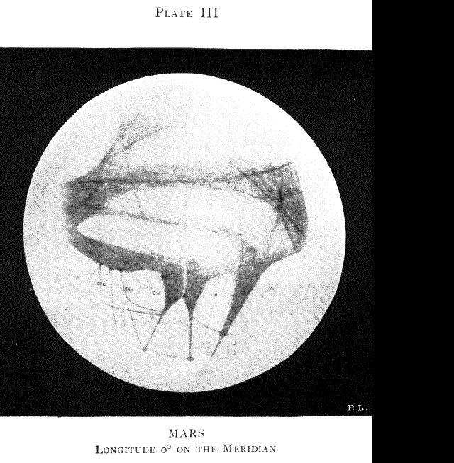 (Plate III.)
It will be noticed that the 0 degree meridian passes through the tip of a triangular peninsula that juts out into a dark area curiously forked, half way across the picture and about two thirds way down it. The tip of this triangle is the received Greenwich of Martian longitudes, and has been named by Schiaparelli the Fastigium Aryn, such having been the name of a mythologic spot supposed by the ancients to lie midway between the east and west, the north and south, the zenith and nadir. It thus makes a fitting name for the starting-point of Martian longitudes and the beginning of time. The dark forked area, called by Proctor "Dawes' Forked Bay," is now commonly called the Sabaeus Sinus. At the times these marine names were bestowed, it was supposed that the dark markings really represented water. We have now reason to believe that such is not the case. But it is better to keep the old names, although I shall employ them in a Pickwickian sense, much as we still speak of the Seas of the Moon, the Mare Tranquillitatis, or the Mare Serenitatis, of which only the adjectives have in them anything of truth.
To the west of the Sabaeus Sinus lies another dark, wedge-shaped area, longer than it but single instead of double. This is the Margaritifer Sinus, or the Pearl-bearing Gulf, so named before it was known that that name possessed any significance. But a prescience must have presided over its christening. For we now know that there is indeed a pearl at the bottom of it,--the round spot shown in the picture.
Two lines will be noticed prolonging the twin forks of the Sabaeus Sinus. If we let our look follow down them, we shall mark others and then yet others, and so we might proceed from line to line all over the bright areas of the planet. These lines are the famous canals of Mars. With regard to their surprising symmetry, it is only necessary to say that the better they are seen the more symmetrical they look. Of
| Previous chapter/page | Back | Home | Email this | Search | Discuss | Bookmark | Next chapter/page |